Petrel model will help Anson plan future Green River lithium extraction wells

The new Petrel model will provide Anson with valuable insights and information about geological formations and reservoirs at its Green River lithium project in Utah. Pic: Getty Images
- Anson Resources’ new Petrel model will help locate extraction and disposal wells at its Green River lithium project
- Model confirms that lithium-rich brine reservoir extends throughout the project area
- Upcoming re-entry well to test theory that two parallel faults concentrate lithium
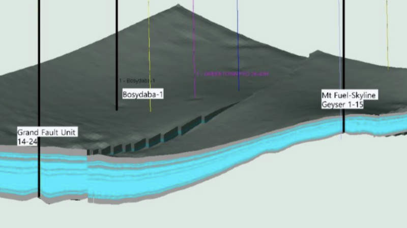
Special Report: Anson Resources has built a static and dynamic Petrel model for its Green River lithium project in Utah that will help determine the location, design and depth of extraction and disposal wells.
The model was constructed by importing the company’s 3D geological model and numerical groundwater flow model into the system to build a comprehensive 3D subsurface model that provides valuable insights and information about geological formations and reservoirs.
Data from additional well logs, including Grand Fault Unit 14-24, were added to that from the original 3D geological model when developing the Petrel model which provided further insights into the selection and design of future drilling programs, JORC resource estimates and engineering and feasibility studies.
What’s particularly significant for Anson Resources (ASX:ASN) is the Petrel model confirmed the reservoir containing the lithium-rich brine extends throughout the Green River project area while the thickness of the target Mississippian Unit increases to more than 700 feet (213m) to the west of the Boysdaba-1 well.
Adding interest, the Grand Wash Fault and the Ten Mile Garben geological units that run through the project area and may form “traps” that concentrate the lithium grades do not seem to extend beyond the project’s area of interest to the west.
Targeting aid
ASN noted the model had identified the Mt Fuels location immediately to the north of Ten Mile Garben as being well suited to determine if the brine minerals including lithium were concentrated by the trap as brine flowed from north to south and may be slowed by the parallel faults.
This theory will be tested during the forthcoming drilling program at Mt Fuel.
Logs from previous drilling at this location indicate that the bottom of the Mississippian Unit was not reached.
Given that the Grand Wash well extends to 668 feet, the company’s re-entry of the historical Mt Fuel-Skyline Geyser well will seek to reach the bottom of the unit providing an opportunity to further increase the JORC resource of 103,000t of contained lithium carbonate equivalent.
The Petrel model also identified more than 42 aquifers with varying thicknesses within the Mississippian Unit.
This information could assist with the identification of priority locations and depth for extraction and disposal wells.
ASN added the model could be used for production and fluid flow simulation, to determine the interaction between proposed wells and predict maximum extraction, which also assisted in the determination of proposed wells.
Results from these tests will then feed into engineering studies that can produce operating cost estimates for production and disposal wells.
This article was developed in collaboration with Anson Resources, a Stockhead advertiser at the time of publishing.
This article does not constitute financial product advice. You should consider obtaining independent advice before making any financial decisions.
Related Topics

Related Stories


UNLOCK INSIGHTS
Discover the untold stories of emerging ASX stocks.
Daily news and expert analysis, it's free to subscribe.
By proceeding, you confirm you understand that we handle personal information in accordance with our Privacy Policy.