

Mining
Fortescue is dialled in to critical minerals; here's some areas the major miner is tuned into

Mining
NickelSearch nails key land access agreement as drill planning kicks off at Carlingup

Mining

The NIS team is building an extensive understanding of the Lithium-Caesium-Tantalum (LCT) mineralisation at Carlingup. Pic via Getty Images
Mining
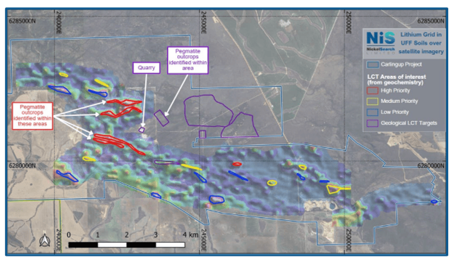
Special Report: A program of in-fill soil sampling has kicked off over four, previously high-priority areas at Carlingup, a project which has attracted the interest of nearby lithium producer Allkem.
NickelSearch’s (ASX:NIS) 108km2 Carlingup project sits on the Ravensthorpe greenstone belt in WA, a region highly prospective for nickel sulphide deposits on the southern margin of the Archean Yilgarn Craton.
This belt is in the same greenstone corridor as IGO’s (ASX:IGO) Forrestania nickel mining complex and adjacent to First Quantum Minerals’ laterite mine, the Ravensthorpe Nickel Operations (RNO).
But despite the long history of nickel exploration in the Carlingup area, and at the Carlingup project itself, which boasts an existing resource base totalling 155,000t of contained nickel, NIS has been focusing its efforts recently on proving up the lithium prospectivity at the site.
This work led to the partnership with lithium producer Allkem (ASX:AKE) during the quarter, owners and operators of the 140,000tpa Mt Cattlin lithium just 10kms from Carlingup, to review the lithium related data and collaborate on target generation and prioritisation.
NIS has now set out to test the lithium prospectivity of the broader Carlingup tenement package with a program of infill soil sampling to test the northwest trending dykes more effectively than the 2021-2022 sampling, which was optimised for nickel exploration.
The samples from the southern two areas have been sent for assay, and the sampling of the northern two areas will be complete in the coming weeks, NIS says.
Mapping and rock chip sampling of four high priority areas of interest, where anomalism for each extended at least 800m, has wrapped up and confirmed the hypothesis that these felsic dykes and pegmatites are related to the geochemical anomalies.
The rock chip sampling program which was carried out in conjunction with the mapping will help to determine the priority and targeting of the areas of interest for further exploration once infill soil sampling has been completed.
NIS has also completed a first-pass soil sampling program testing the areas surrounding the quarry, where NickelSearch confirmed high-grade lithium within spodumene-bearing pegmatites through rock chip results including 5.19% Li20 and 4.99% Li2O.
The area for the soil sampling focused on the surrounding areas, given that the quarry itself is disturbed land. Those samples have been submitted for priority assay.
Further rock chip samples have also been taken to better understand the occurrence and genesis of the pegmatites.
“The NIS team is building an extensive understanding of the Lithium-Caesium-Tantalum (LCT) mineralisation at the quarry, and also of the geology of the land surrounding the quarry,” NIS managing director Nicole Duncan says.
“Within this broader area, which includes four high-priority areas of interest, we’ve mapped, rock chip sampled and have in-fill soil sampling underway. At these four high-priority areas, we have confirmed the presence of pegmatite outcrops, which is encouraging.
“We have completed soil sampling at the quarry, and those samples have been submitted for priority assays,” she says.
In parallel, our geologist continues to map and rock chip sample the quarry footprint, to gain a better understand the occurrence of LCT pegmatites there.”
NIS is in the process of agreeing next steps with the operator of the quarry.
It is intended to expose the bedrock geology where possible to enable a more complete campaign of mapping and sampling of the quarry area.
This includes the draining the quarry pit of water, and exposing the floor of the quarry pit which is currently sheeted with gravel.
This article was developed in collaboration with NickelSearch, a Stockhead advertiser at the time of publishing.
This article does not constitute financial product advice. You should consider obtaining independent advice before making any financial decisions.
Mining
Mining
Mining

Mining

Mining

Mining


Get the latest Stockhead news delivered free to your inbox.