Rivers of Gold: Lefroy gets closer to the source at Red Dale
Pic: John W Banagan / Stone via Getty Images
Special Report: Kalgoorlie explorer Lefroy (ASX:LEX) has finished a new drill campaign at the Red Dale prospect, designed to expand the existing ~20,000oz resource while dialling in on the source of this gold in the deeper bedrock.
The gold mineralisation at Red Dale is located in the gravels of a 30-million-year-old buried riverbed called a ‘paleochannel’.
Gold was first identified at Red Dale by Integra Mines in 2007 — since acquired by Silver Lake (ASX:SLR) – the same year it discovered the Salt Creek deposit, 2.5km to the south.
Drilling between 2007 and 2010 identified a sizeable regolith-hosted gold anomaly about 1.6km long and up to 1km wide.
Regolith is the ‘loose’ oxide dirt which covers the solid fresh bedrock deeper down.
A new 35-hole program by Lefroy has now extended this gold mineralisation by 360m immediately north of the existing resource.
Numerous significant shallow oxide gold intersections were recorded, including 3m at 2.03 grams per tonne (g/t), 45m from surface.
The main gold-bearing paleochannel is now 840m long and still growing. This drilling also hit two possible ‘tributaries’ that adjoin the main channel.
It is interpreted that each of these tributary drainages also contain gold bearing gravels and sands, Lefroy says.
Lefroy says there’s an opportunity to find more shallow gold in the tributaries, as well as potentially multiple primary sources.
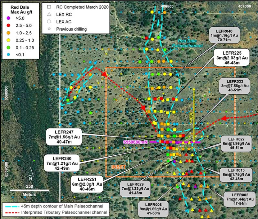
The gravel horizon (1-3m) contains coarse quartz fragments that the company interprets to be sourced from a primary source just to the north of the drill area. This material is unlikely to have travelled far, Lefroy says.
The next step is to update the resource model with new drill data, which is expected to be completed in June 2020.
This data will also be used to develop a ‘palaeosurface digital terrain model’ (DTM) – a 3D image of the ancient landscape which will deliver improved definition of the channels and potential gold depositional sites.
This is expected to be completed in May and used for drill planning.
Trying to determine the flow of an old riverbed requires a bit of detective work, Lefroy managing director Wade Johnson told Stockhead.
“The gold was sourced from the underlying, much older rocks somewhere,” he says.
“We are using the gold in the channel to try and locate the source (or sources), but along the way if we keep enhancing the paleochannel resource that’s good also.”
This story was developed in collaboration with Lefroy Exploration, a Stockhead advertiser at the time of publishing.
This advice has been prepared without taking into account your objectives, financial situation or needs. You should, therefore, consider the appropriateness of the advice, in light of your own objectives, financial situation or needs, before acting on the advice. If this advice relates to the acquisition, or possible acquisition, of a particular financial product, the recipient should obtain a disclosure document, a Product Disclosure Statement or an offer document (PDS) relating to the product and consider the PDS before making any decision about whether to acquire the product.
Related Topics

Related Stories


UNLOCK INSIGHTS
Discover the untold stories of emerging ASX stocks.
Daily news and expert analysis, it's free to subscribe.
By proceeding, you confirm you understand that we handle personal information in accordance with our Privacy Policy.