There's lithium! Pic: via Getty Images
On target: Critical Resources’ lithium expansion strategy continues
Mining
There's lithium! Pic: via Getty Images
Mining
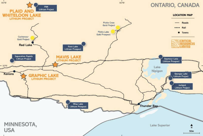
Expanding lithium footprint in the “Electric Avenue” region of northwest Ontario, Canada.
Critical Resources (ASX:CRR)has expanded its lithium landholding in Ontario with the acquisition of the Plaid and Whiteloon Lake projects just 5.5km from Frontier Lithium’s PAK, Spark and Bolt deposits.
PAK is one of North America’s highest-grade and highest tonnage hard rock lithium deposits with a high confidence Measured and Indicated resource of 10.49Mt averaging 1.78% Li2O and an Inferred resource of 18.48Mt grading 1.45% Li2O.
This is encouraging given that pegmatite mineralisation has been observed across both the Plaid and Whiteloon Lake projects, which cover a total area of 4,500 hectares.
“The Electric Avenue region is a highly prospective area hosting large and high grade hard rock lithium projects, so to be able to acquire land in this area is a very exciting development for the company,” Biggs added.
Assays from 12 rock chip samples and one float sample obtained across one of Critical’s other Candanian assets, demonstrating elevated levels of lithium while anomalous rare element enrichment suggests that a lithium-caesium-tantalum type system is present.
The companyhad consolidated the 2,100 hectares of claims that make up Graphic Lake, which covers a pegmatite swarm trending northeast-southwest with a width of 300m and an estimated strike of 5.5km within the Sioux Lookout Domain of the Wabigoon Terrane, earlier this month.
“It is an excellent outcome to receive assays that confirm lithium enrichment at Graphic Lake,” managing director Alex Bigg said.
“As an early stage project, we feel that we can employ a strategic and structured exploration strategy to begin delineating further mineralisation with a target of defining a JORC compliant resource.
“Our initial focus will be on proving geological continuity before defining drill targets.”
At Graphic Lake, the company plans to expand surface mapping and sampling of outcrops to assist in the identification of drill targets in conjunction with the planned airborne survey data.
Channel sampling will also be carried out on areas of interest previously identified by outcrop mapping and sampling.
Data from these programs will assist targeting for a preliminary 2,500m drill program.
A secondary drill program of about 5,000m will be designed based on the preliminary results and data interpretation from previously outlined exploration activities.
Critical will also complete a diamond drilling program once drill targets are defined across the Graphic Lake tenements.
Over at the new projects, the company will carry out surface mapping and sampling of outcrops. This will be combined with data from a planned airborne survey to assist in the identification of drill targets.
Further surface mapping may identify new pegmatites not previously documented.
Additionally, channel sampling will be conducted on areas of interest previously identified by outcrop mapping and sampling.
This article was developed in collaboration with Critical Resources, a Stockhead advertiser at the time of publishing.
This article does not constitute financial product advice. You should consider obtaining independent advice before making any financial decisions.


Get the latest Stockhead news delivered free to your inbox.