Pic: Tyler Stableford / Stone via Getty Images
These pilotless drone robots are helping miners cut costs
Mining
Pic: Tyler Stableford / Stone via Getty Images
Mining
Miners are cutting costs by as much as 20 per cent by using unmanned drones, according to Israeli automated drone start-up Airobotics.
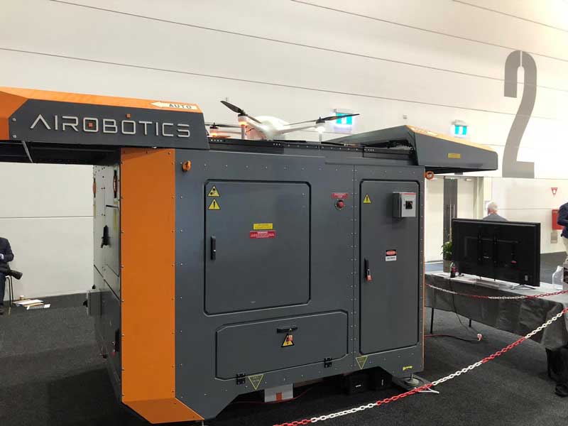
Airobotics, which works with the likes of mining heavyweights BHP (ASX:BHP), Vale and South32 (ASX:S32), has developed a completely autonomous drone system.
The system comprises a large airbase, or docking station, that stands 2.5m tall and weighs 3 tonnes.
The drone takes off from and lands on the docking station, and everything from charging and replacing the batteries and cameras to downloading the data is controlled by a “robot”.
“The reason why we built it this way, without a human in the loop, is because the number one reason for safety incidents is human error,” vice president of marketing Efrat Fenigson told Stockhead on the sidelines of the recent International Mining and Resources Conference in Melbourne.
“So we wanted to automate the whole process from the flight of the drone to the data processing and analytics.”
Airobotics’ drones can be used for surveying and mapping, security and emergency response, stockpile management, haul road optimisation, inspection of infrastructure and to monitor the risks of tailings dams.
The management of tailings dams in particular has come under scrutiny in recent years following the collapse of the dam at BHP and Vale’s Samarco iron ore mine in Brazil.
The dam burst in November 2015 releasing millions of tonnes of toxic mud that wiped out the nearby village of Bento Rodrigues and killed 19 people.
It was said to be the largest environmental disaster in Brazil’s history, costing BHP hundreds of millions of dollars for the clean up and compensation.
Structural damage was a factor cited in the investigations of the incident.
This is where drones come in handy, according to Airobotics.
Drones can undertake routine data-collection that can help with early detection and prevention of a dam failure.
Engineers can monitor the strength of dams by combining historical and real-time data, which improves engineering, management, safety and control of tailings dams.
Airobotics already has drones in operation at several mine sites in Western Australia and at Vale’s nickel mine in New Caledonia.
The company has its “beyond line-of-sight” certification from the Civil Aviation Safety Authority, so the drones do not always need to be seen.
Airobotics says it is the first and only drone solution worldwide certified to fly without a human operator.
All of Airobotics’ systems in Australia are monitored from the company’s remote operation centre in Perth.
Ms Fenigson says miners are realising their return on investment (ROI) quite quickly.
“This is a premium product, it’s not a cheap product, but when you use it on a very frequent basis — so several times a week — it’s already justifying itself,” she explained.
“Our customers are creating the business case and ROI for this very, very quickly. Within the first year of using this they’re already saving money.”
While every mine site is different and will use the drones for different tasks, some miners are realising double digit productivity savings.
“Some of our mine sites have shown us that they’re saving a good 20 per cent of productivity in some of the work that we do for them,” Ms Fenigson said.
“They’re definitely saving money.”
Airobotics’ drones are currently used for open pit mines, but not yet for exploration or underground mines.
The company is considering a move into exploration — which requires drones to cover larger distances — later down the track.
Going underground
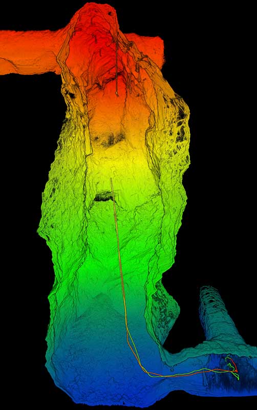
Meanwhile, the CSIRO has developed technology that enables drones to be used in underground mines.
CSIRO spin-off Emesent has just raised $3.5 million to take its “Hovermap” technology to market.
Last year, Emesent conducted the world’s first fully autonomous beyond line-of-sight drone flight in an underground mine, 600 metres below the surface, in Western Australia.
Drones installed with Hovermap can be used to collect data in underground areas too dangerous or difficult for people to survey.
They can be used in areas where GPS doesn’t work, and without a human controller, to create 3D maps, and record gas readings, videos and images.
The Hovermap system is already being used commercially for a variety of applications by early adopters in Australia, the US, Canada, China and Japan.
Drones going mainstream
Oren Elkayam, the co-founder of Israeli tech play Mobilicom (ASX:MOB), said at a recent industry event that the years 2019 and 2020 would see significant jumps in the use of drones and the drone market generally.
Mobilicom makes communications equipment for drones and robotics.
Goldman Sachs estimates drones are a $100 billion market opportunity, with MRFR forecasting the market will grow a whopping 30 per cent annually.


Get the latest Stockhead news delivered free to your inbox.